Key Enhancements
This release delivers the following key enhancement and several other enhancements, which are listed below:
3D Map Feature Enhancements
This enhancement allows the users to access 360-degree views of properties by tilting or rotating the satellite imagery to get a better understanding of the contours and elevation of the site’s terrain. The 3-D capabilities will make TitleFlex even more useful to real estate investors, builders, utility companies and surveyors.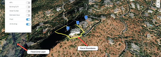
3D MAPS: A FULL INTERACTIVE PARCEL & TERRAIN VIEW
Key Capabilities
- • 3-D Map feature will optimize land surrounding features such as slope and elevation
- • Users can assess a property in both 2-D and 3-D views, with consistent layering capability (e.g., parcel boundaries, 3-D structure overlays, flood zones, etc.)
- • Ability to pan around on 3-D Map with zoom capabilities
- • Compare 2-D and 3-D Views on separate desktop monitors
- • Ability to select new subject property through 3-D Map and 2-D Map
- • Multiple property selections can be enabled on the map
Why This Is Important
- • Static 2-D and 3-D Oblique maps only provide a partial, flat view of the parcel and surrounding area. Viewers cannot see the contour of the terrain to understand if the lot is buildable.
- • Robust layering capability (e.g., parcel boundaries, structure overlays, valuation estimates, etc.) combined with 3-D views.
- • Cost-effective 3-D capabilities and layering at scale, nationwide.
For additional information on this release, please contact the DataTrace Customer Success team at 800.221.2056 or customersuccess@datatracetitle.com